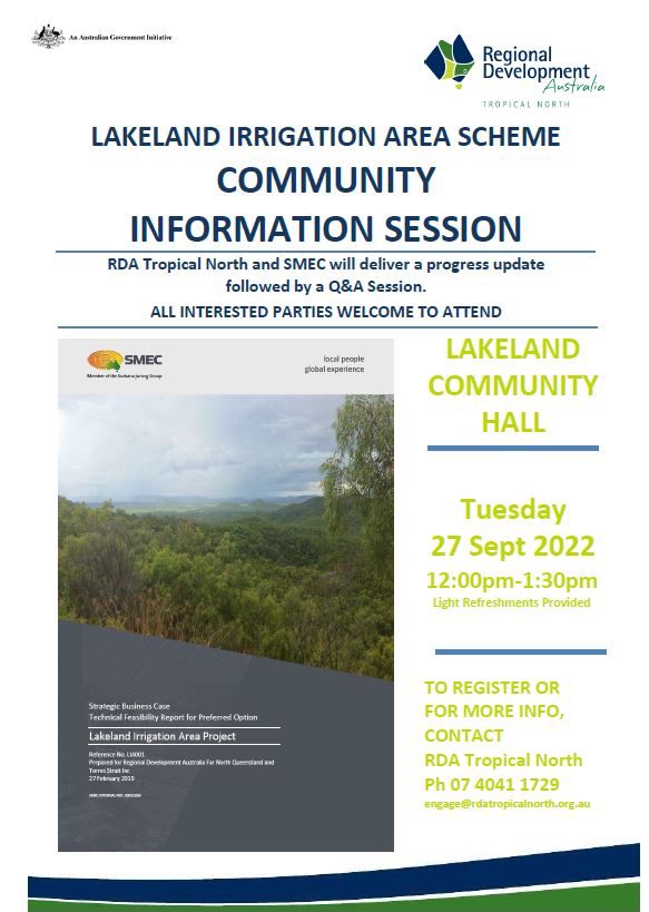
Lakeland Irrigation Area Scheme
Benefits to the region include:
- Access to a reliable, adequate and affordable water supply capable of supporting a majority of soils suitable to horticulture and broadacre cropping in the Lakeland Irrigation Area.
- Ability to grow higher value and more diverse range crops in suitable areas
- Improved confidence of irrigators to invest in long term business operations
- Benefits to regional business activity and prosperity through increased agricultural activity
- Potential increase in population with a wider range of community services
Overview
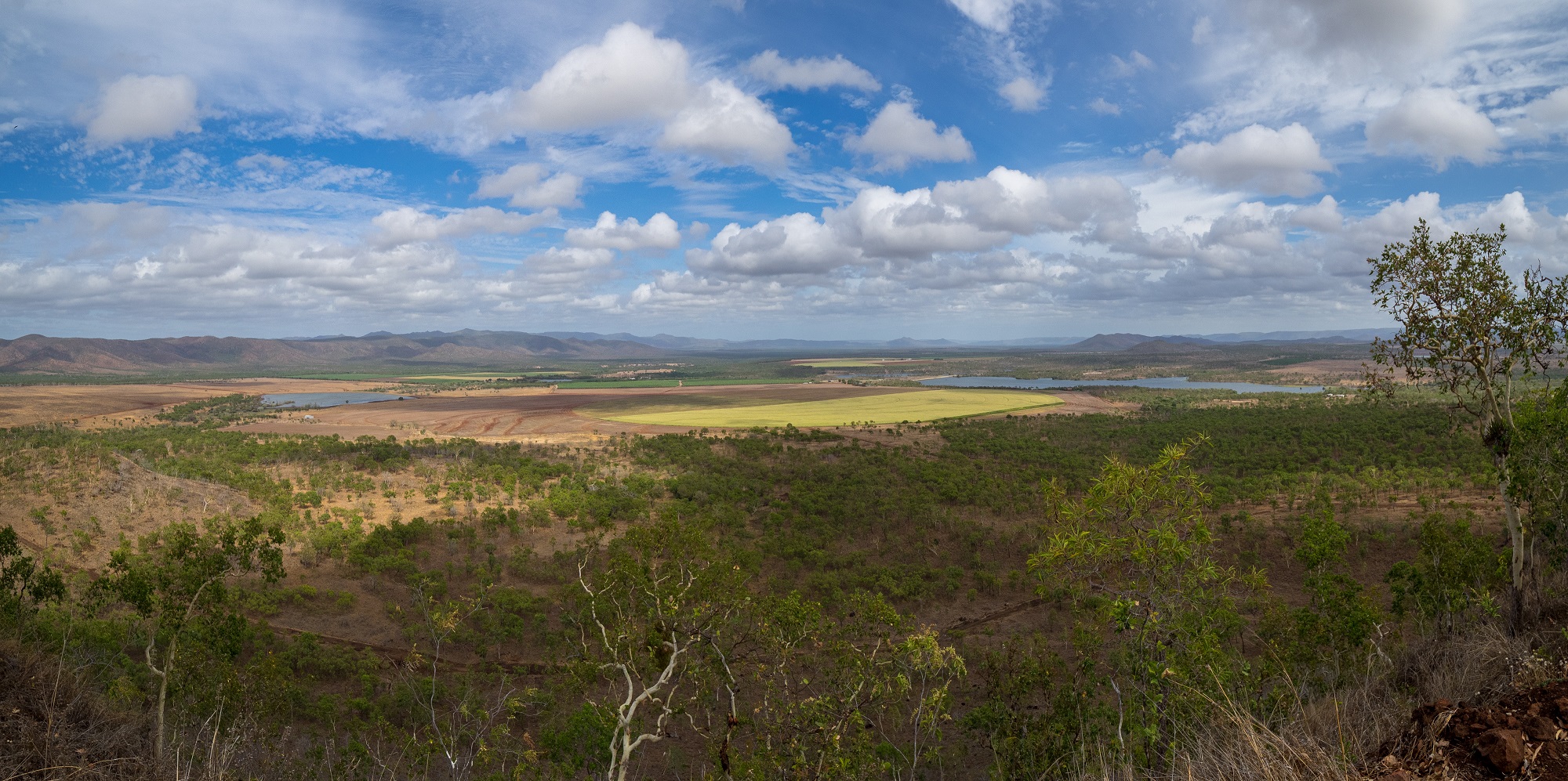
The Lakeland Irrigation area was established over 70 years ago and boasts rich basalt soils growing a variety of crops. Water availability and security is the major inhibitor to the success and expansion of agriculture in the region. At present less than 2,000ha is being irrigated. Lakeland is situated in the Laura River basin draining into the Great Barrier Reef.
The Department of Resources has completed a comprehensive soil and crop analysis of the Lakeland basin as part of the strategic business case. This report identifies numerous opportunities for diversity.
In 2017, Cape York Sustainable Futures (CYSF) received $825,000 (ex GST) to undertake the Lakeland Irrigation Area feasibility study to explore, identify and assess all aspects of expanding and improving agriculture in the LIA. The LIA feasibility study was part of the National Water Infrastructure Development Fund (NWIDF), an initiative of the Australian Government. CYSF engaged SMEC and the then Department of Natural Resources, Mines and Energy (DNRME) to undertake a Land and Soil Assessment. A total of 17,115 ha of irrigable land was identified in the area.
The report assessed four options, identifying the Palmer River at the headwaters of the Mitchell River catchment as the most favourable site. The Palmer River, a tributary of the Mitchell River, flows west into the Gulf of Carpentaria and avoids the prospect of a major dam, on a river flowing to the Great Barrier Reef lagoon.
Following the closure of the Cape York Sustainable Futures (CYSF) in 2018, RDA Tropical North (then RDAFNQ&TS) entered into an agreement to deliver the draft and final Strategic Business Case-Technical Feasibility Report.
RDATN has worked with Federal and State Governments to progress the project further, receiving $10m in funding to undertake the Detailed Business Case (DBC).
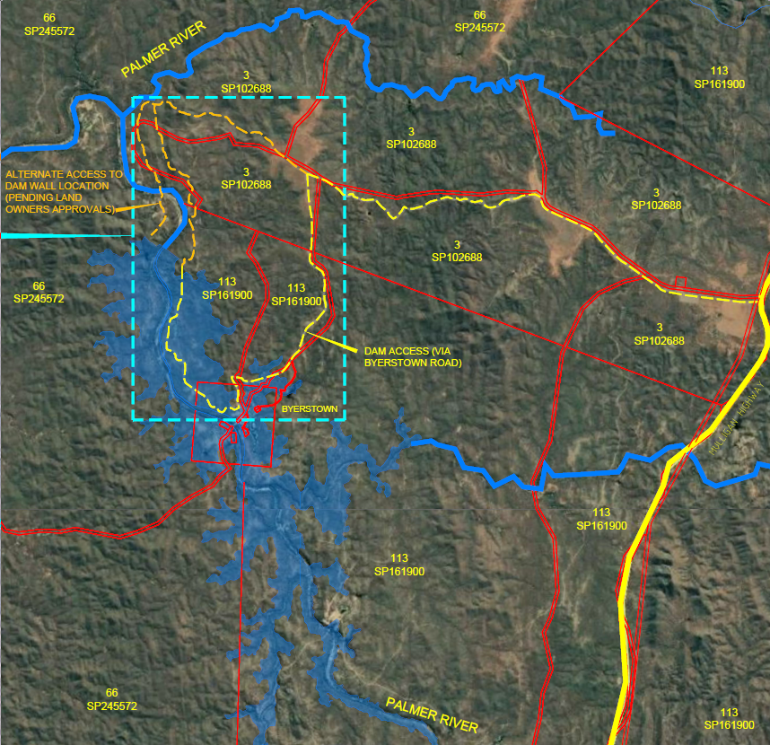
SMEC was appointed as the principal project manager and a Reference Group was established to provide feedback to the detailed business case. The DBC investigated the viability of infrastructure as well as the economic viability of supplying water to the Lakeland farms. The current proposal is to construct a dam up to 296,000ML with an annual offtake up to 105,000ML. The reference design defines the method of transfer of water from the dam by either surface pipes or a tunnel, which is preferred. An indicative distribution scheme is also included.
The scheme will service up to 10,000Ha of arable freehold land with no further tree clearing required.
The project will provide both economic and social benefits to a sparsely populated area with potential for growth in population and services.
The Detailed Business Case, including a detailed submission from RDATN has now been completed; it has been lodged with the Queensland State Government Department of Regional Development, Manufacturing and Water as well as the Commonwealth’s National Water Grid Authority and is now publically available.
LIAS Business Case Reports (Last Updated: MAY 2024)
LIAS Images, Maps and Flyover Animation
LIAS News and Community Info (Last updated: MAY 2024)
LIAS FAQ (Last updated: DEC 2024) - What is the project objective?
SBC – Strategic Business Case
DBC – Detailed Business Case
Q: What is the project objective
A: Lakeland is an area of arable red soil 180km north of Mareeba. It currently irrigates about 1,800ha of mixed crops using a mix of farm dams and groundwater. Its current constraint is lack of water to enable expansion to at least 10,000ha of irrigation.
LIAS FAQ (Last updated: DEC 2024) - What investigations have been carried out?
SBC – Strategic Business Case
DBC – Detailed Business Case
Q: What investigations are being carried out?
A: Commencing in 2017, a Feasibility Study and Strategic Business (SBC) was conducted resulting in a final recommendation in early 2019. A subsequent Commonwealth government grant commencing in 2020 resulted in a Detailed Business Case (DBC) which was published in April 2024. Both studies were conducted by SMEC as principal consultant.
LIAS FAQ (Last updated: DEC 2024) - What does the project involve?
SBC – Strategic Business Case
DBC – Detailed Business Case
Q: What does the project involve?
A source of water has been identified from the headwaters of the Palmer River 24km south east of Lakeland. The scheme as proposed consists of:
296,000 Megalitre dam.
- This is the larger option recommended by RDATN.
- This dam will allow additional areas on Lakeland to be directly serviced including Crocodile Station, an Indigenous property.
- The dam is also adjacent to Bonny Glen Holding, also an Indigenous property, which has areas of good quality agricultural land and could be serviced by an alternate offtake from the dam.
- 3,197 hectares flooded including Byerstown, Byerstown reserve is 260ha, individual parcels total 60ha.
- Geological conditions at the dam site are not fully understood, having only been investigated by a relatively small number of boreholes, but issues are possible due to the known location of the Palmer River Fault and rock conditions that showed high water losses under testing.
- The detailed geotechnical reports are included in the DBC. The DBC was constrained by the budget of $10million and the scale of geological testing (nine boreholes for dam and saddles) is consistent with the funding and the project stage. The report acknowledges the implications of the Palmer River fault, and particularly the soundness of the foundations on the right abutment (looking downstream).
- The design as proposed provides for worst case conditions including extensive rock stabilisation and deep cutoff walls. At this stage that is all that can be done. In addition, the design includes a contingency for unknown factors of over $170 million against a ‘base’ cost of $420million. The next stage will involve detailed design supported by significant additional geotechnical testing and it is anticipated that more than 30 boreholes will be required. This is not unusual (the Charleston Dam at Forsayth had 30 boreholes for a much smaller dam). The detailed design and geotechnical investigation are anticipated to need around $30 million to satisfy these requirements.
3m diameter 12km long transfer tunnel
- This tunnel will transfer water under gravity from the dam through the Great Dividing Range.
- Two boreholes have been drilled along the 12 km tunnel route. This limited data raises risks for cost and timeline overruns, despite allowances in the projected costs.
- The original proposal was to drill three (3) boreholes for the tunnel, however the project team’s inability to access the Bonny Glen site limited these to two boreholes. The two (2) bore holes were quite deep and angled to intercept potential unstable areas and gain a good cross section of the geology. Notwithstanding, there was no indication of adverse geological conditions. Final design will require significantly more boreholes and may potentially require a pilot tunnel along its length. A contingency of 30% has been allowed in the DBC estimate.
- This option was compared against a surface route (buried pipeline), but this was found to be about the same cost but requiring additional holding dams to balance water supply to irregular irrigation timing, as well as having the potential for significant surface disruption of environmental and cultural heritage values.
- Both surface and tunnel options provide opportunities for hydro generation, but both need to offset high residual pressures in distribution pipelines to farms, to mitigate safety concerns.
- Installation of mains power at the remote dam site is also required to power the large pumping system for surface transfer, while the tunnel design allows for on-site renewable energy solutions to operate mainly control equipment.
74km of pipe distribution to farms,
- The distribution system supplies two distinct areas with up to 100m elevation difference
- 34 km of pipes in high elevation zone in the north east
- 40 km of pipes in low elevation zone towards the west.
- Expected to result in 10,000 ha of irrigated agriculture
Changes have been made to the pipeline materials as requested by the state department to address risks caused by the high pressure that will occur due to the gravity transfer through the tunnel, although further consideration will be needed to determine whether the risks have been fully addressed.
The distribution system has been designed, based on growers’ wishes, to have sufficient residual pressure in the pipeline to operate the irrigation equipment. This avoids every farmer having to procure mains power for pumping and realises efficiencies in power even if this was generated by hydro. Hydro needs to convert the potential energy resulting from height differences into electricity, before distribution to farms. This is less efficient than pressure energy, which is only impacted by pipe and fitting friction, which still exists for normal distribution under pumped irrigation.
The alternative to high pressures in the pipelines is to construct a balancing tank at the base of the Dividing Range and then pumping water into the distribution system at lower pressures, still requiring farmers to purchase mains power for irrigation. Preliminary investigation did not locate a suitable site for this facility.
It is recognised that the final proponent for the scheme may well opt for an alternate transfer system from dam to farm, depending on its own economic analysis.
LIAS FAQ (Last updated: DEC 2024) - Were there other sources of water available?
SBC – Strategic Business Case
DBC – Detailed Business Case
Q: Were there other sources of water available?
A: The Qld Departmental Statement on the Detailed Business Case refers to other options for a water source, identified through the Strategic Business Case. Unfortunately, as outlined in the DBC preamble, other options outlined in the Strategic Business Case do not meet the project’s objectives of ‘substantially increasing the irrigable area at Lakeland to around 10,000ha’, leaving it to a future proponent to decide what solution to adopt.
The other options included:
- Dams on either the East or West Normanby Rivers: The East Normanby was discounted early as it was situated in National Park. Both of these rivers flow into the Great Barrier Reef lagoon and have substantially smaller catchments than the Palmer Dam. This would mean that to release 5,000ha of irrigable land, all of the annual flow would be captured, with no provision for environmental flow. In addition, the West Normanby sites are located on Springvale Station which is now classed as Nature Refuge.
- Extension of and additions to existing farm dams: These are all situated on minor gullies near the top of the Laura River catchment. Even with the augmentation investigated, the area able to be irrigated was only marginally larger than the 1,828ha at present, by lifting the current reliability from 50% (1 in 2 year failure) to 70%, the recognised norm.
LIAS FAQ (Last updated: DEC 2024) - What is the cost of the scheme?
SBC – Strategic Business Case
DBC – Detailed Business Case
Q: What is the cost of the scheme?
A: The total scheme cost in 2023 dollars is about $2billion. This includes contingency provisions of around $500million.
| COMPONENT | Base Cost | Fishway Provision | Common Pro Rata | Client Cost Pro Rata | Contigency Pro Rata | Total |
| Palmer River Dam (396GL) | $422 | $100 | $143 | $19 | $176 | $861 |
| Tunnel Using TBM 3.0m ID | $236 | – | $80 | $11 | $98 | $425 |
| Irrigation Water Distribution Network | $357 | – | $121 | $16 | $149 | $644 |
| Site Access Roads | $22 | – | $7 | $1 | $9 | $40 |
| Miscellaneous | $54 | – | $18 | $2 | $23 | $97 |
| Subtotal | $1,091 | $100 | $371 | $50 | $455 | $2,067 |
LIAS FAQ (Last updated: DEC 2024) - Is the scheme commercially viable?
SBC – Strategic Business Case
DBC – Detailed Business Case
Q: Is the scheme commercially viable?
A: The Qld Departmental comment states: “The project’s high construction costs and low economic benefits pose significant challenges. The benefit-cost ratio is estimated between 0.13 and 0.37, meaning only a small fraction of the capital cost will be recovered. The project does not meet cost recovery expectations and would require substantial grants and subsidies.”
- The costs for this project is not high when assessing each component, for example, around $800million has been spent on the Rookwood weir (Fitzroy River), which does not include the $1billion allocated for the pipeline to Gladstone. The Queensland government also allocated $1.2billion for a replacement Paradise Dam, not including original construction and demolition to date. An estimate of $14billion was also made for the Borumba pumped hydro scheme.
- The current guidelines in Australia for water supply requires a return on investment over a 30-year infrastructure lifespan – hence the comment regarding ‘low economic benefits’. While this is standard methodology for comparison between infrastructure schemes, this does not recognise that such infrastructure (mainly dam and tunnel) will have a life in excess of 100 years, subject to regular maintenance. The assumption is that the growers will pay for the scheme and therefore their annual costs would be excessive particularly over a short time span. However, as has happened in other schemes where the project has a long time span, it may be appropriate for government to fund the major infrastructure. This would recognise the nation-building status of the project and its long-term benefits to the economic growth of the region and Cape York Peninsula.
- Without significant government assistance, the Lakeland Scheme would be the only scheme in Queensland and possibly Australia, where government would not be underwriting all or most of the capital costs. It is unlikely that the Tinaroo and Mareeba-Dimbulah Scheme would have proceeded if that had been the case. If governments were to fund the infrastructure, then the water allocation and annual operating costs to farmers would be within the range of other water supply schemes in Queensland.
- The DBC does identify significant regional returns based on the flow-on effects of the establishment of Lakeland as a service centre, both in terms of Gross Regional Product (GRP), and employment and population growth. Consideration of Lakeland within this regional context, rather than as an isolated scheme, would provide more incentive for government assistance. The following section highlights the increase in GRP of up to $213million per year from farming alone, and a further $500milion per year for Cook Shire through growth of Lakeland as a service and commercial centre.
- It will be up to governments to determine the future of this scheme and the funding arrangements.
- The strict interpretation of the current guidelines is that the funding and economic costs need to be transparent, and that is what will occur going forward.
LIAS FAQ (Last updated: DEC 2024) - What are the benefits of the scheme beyond those for the farmers?
SBC – Strategic Business Case
DBC – Detailed Business Case
Q: What are the benefits of the scheme beyond those for the farmers?
A: The project as a means to provide more water to Lakeland and expand its area is supported by Cook Shire Council who see it as a critical resource to increase economic activity in the Shire (and therefore long-term viability) through infrastructure, industry, employment and the permanent increase in population.
The project was initiated by current growers in 2015 based on a water shortage, to support the fertile soils of Lakeland, with noting that two failed wet seasons in Cape York will drastically impact food production; this is advocated in the front of the submission to DRDMW.
The project is supported by the Western Yalanji Aboriginal Corporation as critical to their long-term goals and is also in the submission.
The Business Case researched 23 Local Government Areas (LGA) across Australia (Cummings CE Ref-j3448 Schedule 11A) on the following basis:
- Agricultural production being the dominant economic basic activity in the area;
- Significant proportion of horticultural production.
This analysis identified the likely supported population per $100million of agricultural sector production – in the order of 2,500 persons. The average ratio across Australia ranged from 2,000 to 4,000 per $100million.
Based on the impact of agricultural sector production from this analysis, the suggested increase in population from the Lakeland Scheme and its flow-on effects would be:
- Cook Shire………………………..…13,000 – 15,000
- Cooktown……………………………..2,700 – 3,300
- Lakeland Township………………..3,600 – 4,400 (From a current permanent base of 314)
- Lakeland District……………………7,300 – 8,800
- Mareeba…………………………..…10,000 – 11,000
- Cairns………………………………..….3,000 – 4,000
Total GRP for Cook Shire would be of the order of $780million/yr.
This includes an amount in the order of $510million/yr on top of current GRP.
Current agricultural production for Cook Shire is less than $40million. The Lakeland Scheme is projected to have a farm revenue around $300M per year supporting a GRP of about $213M per year. These amounts do not include the flow-on benefits to the region from establishment of Lakeland as a service centre.
LIAS FAQ (Last updated: DEC 2024) - Is there sufficient Allocated Water in the Mitchell Catchment?
SBC – Strategic Business Case
DBC – Detailed Business Case
Q: Is there sufficient Allocated Water in the Mitchell Catchment?
There is insufficient unallocated water in the current Mitchell Water Plan to meet the project’s needs. The water plan expires in 2027, and while a review could increase available water, there’s no guarantee this will happen or meet the project’s full requirements.
However, the Mitchell River has the most volume of outflow of any Queensland River (15,570GL compared with Gilbert R at 3,706GL), and less than 1% is currently allocated. The Lakeland project will, with allowance for evaporation, take less than 1%. The Mitchell River Water Plan expires on 27 November 2027, and it is anticipated that the review will be completed by then. There has not been any suggestion that additional water cannot be taken from the Mitchell, and the Minister’s review in 2017 acknowledged a possible requirement for Lakeland.
LIAS FAQ (Last updated: DEC 2024) - Potential Impacts
SBC – Strategic Business Case
DBC – Detailed Business Case
Potential Impacts
There are potential economic, social, cultural and environmental impacts and opportunities associated with the water supply scheme.
The DBC provides a scientific and evidence-based assessment of these potential impacts.
Hydrology
Downstream Impacts:
The Palmer River is a tributary of the Mitchell River which discharges to the Gulf of Carpentaria near Pormpuraaw. There would appear to be little impact on the Mitchell River or outflow to the Gulf. The extensive hydrological studies showed that impact rapidly decreased downstream of the Dam site and was negligible below the junction with the Palmer River.
This is due, for the Palmer, to the impact of other watercourses entering the 300km between the dam and the confluence with the Mitchell River. Below this junction, the hydrology modelling shows there is significant contribution from other water sources as well as a wide distribution of flood waters across the increasingly wide flood fan below the Palmer junction.
The following tables set out the impact of the dam on stream flow, bearing in mind the likely uncertainties of the flood modelling in the lower reaches, e.g when will breakout to other channels occur, and which events and sub-catchments will cause this.
| Location | Pre-development Mean Annual Flow (ML/yr) | Irrigation offtake (ML/yr) | Irrigation offtake Percentage (%) of Mean Annual Flow | Direction Evaporation (ML/yr) | Direct Evaporation Percentage (%) of Mean Annual Flow | Environmental Flows at dam outlet (ML/yr) | Environmental Flow Percentage (%) of Mean Annual Flow |
| Palmer River Dam | 222,810 | 94,453 | 42.4% | 27,943 | 12.5% | 28,964 | 13.0% |
| Palmer River Catchment end (Drumduff) | 1,337,856 | 94,453 | 7.1% | 27,943 | 2.1% | 28,964 | 2.2% |
| Mitchell River at Dunbar | 6,418,778 | 94,543 | 1.5% | 27,943 | 0.4% | 28,964 | 0.5% |
| Outlet (Gulf of Carpentaria) | 15,570,000 | 94,543 | 0.6% | 27,943 | 0.2% | 28,964 | 0.2% |
| Location | Pre-dam Mean Annual Flow (ML/yr) | Irrigation offtake and evaporation – Reference Project Only (ML/yr) | Irrigation offtake and evaporation – Reference Project Only (%) |
| Palmer River Dam | 222,810 | 115,623 | 51.9% |
| Outlet (Gulf of Carpentaria) | 15,570,000* | 115,623 | 0.8% |
| *CSIRO (2018) |
To date there is no indication that this reduction in flow will have measurable economic consequences downstream.
Extensive modelling has occurred to identify potential impacts on downstream properties resulting from a “dam failure”. This situation is a mandated requirement of State legislation and assumes that despite best efforts, a dam failure could occur and a comprehensive risk and management plan is required for any waterway barrier which could place more than two people at risk of serious or fatal consequences. As a result, the design of structures is heavily scrutinised to provide the best possible safety outcome for the community.
Environment
As an approximation, the areas impacted would be the inundation area of around 3,700ha, plus potentially the 10,000ha of irrigated land, minus the already cleared land which would not generally create an impact. During the Environmental Assessment the proposed irrigable land was assessed for areas of uncleared environmental vegetation and this was not included in the final irrigable area of 10,000ha.
This means that to reach 10,000ha, there will be some clearing of vegetation required on the agricultural area. This vegetation is currently classed as ‘of least concern’. Such approval, if given, would result from overall consideration as a Coordinated Project and its Environmental Impact Statement.
The DBC recognises that there are natural values, mainly around the dam site. Inundation will destroy the underlying vegetation and depending on the regional spatial distribution of both vegetation and fauna, will have impacts. The natural values of the site are not unique based on the level of investigation taken to date. It is part of a generally homogeneous regional ecosystem. The specific field results demonstrate this to some extent. While the literature identifies a large number of fauna and flora species as potentially present, there are few sightings of the Matters of National Environmental Significance and Matters of State Environmental Significance instances.
The literature search identified four (4) threatened flora species likely to be present in the project sites. The project found a total of 233 flora species through field surveys, however only one (1) of the four (4) threatened flora species was identified on site, and this was not endemic to the site.
The literature also identified 18 threatened fauna species likely to be present in the project sites. The project found a total of 213 fauna species through field surveys, however only four (4) of the 18 threatened species were identified on site, and none were endemic to the site.
The DBC also includes assessment of the likely Greenhouse Gas impacts.
The future Environmental Impact Statement will clarify the impact on both the threatened flora and fauna and the disturbance to the overall regional ecosystems. This will also determine if the impacts are significant and if so, can be offset through practical or monetary means.
The DBC did not identify any ‘show stoppers’ resulting from environmental assessment.
Fish Passage
Plans for fish transfer at the dam have not been finalised. Proposed solutions include a fish lift and a flushing lock, but costs cannot be confirmed until design options are developed.
The designers proposed a ‘trap and haul’ option similar to that operating at the Hinze Dam which, based on published data, has worked well. It was considered that due to the isolated location this option would be best as it does not rely on costly maintenance of mechanical components and provides an opportunity for Indigenous employment and participation, which was welcomed by local Indigenous peoples.
The government agencies advised they did not agree with this option, preferring instead a fishladder.
The fishladder proposal at this site is not considered feasible by the design team, as it requires an engineered structure to allow fish to move from river bed to top of the dam during periods of significant flow. There are limitations on the height difference between resting pools as well as the length of pools, so setting a minimum slope for the fish ladder.
In this location, and given the operational fluctuation in water levels in the dam of up to 18metres, there would be significant earthworks cuts, up to 50m for a southern fishway, and multiple entrance points into the dam or wall all compromising the structural integrity of the dam wall.
To accommodate this uncertainty, there is no allowance in the current design for a fish passage. Instead, in addition to the dam cost, $100million has been allowed as a separate contingency. The preferred fish passage is now a fish lift and flushing lock similar to that constructed for the Rookwood weir on the Fitzroy River, though this weir is only half the height of the Palmer Dam.
Cultural Values
Field surveys to identify environmental and historical cultural values or artifacts have not revealed any obvious Indigenous cultural heritage sites, other than for European or Chinese heritage from mining. A full Cultural Heritage survey was not undertaken due to the inability for the design team to obtain meaningful engagement from Indigenous parties, and while the historical survey was open to noting any potential sites, none were found. Extensive discussion did take place with the senior ‘elder’ for the country who supported the view that pre-existing artifacts at the dam site, which would be predominantly near water, would have been extensively disturbed by prior mining activity.
Any future stage will include a full survey, and if a scheme is approved this will include Indigenous Land Use Agreements (ILUA) with the relevant and appropriate representatives.
It should be noted that the authorised Native Title body Western Yalanji Aboriginal Corporation has supported this project as a means to return to Country, and initiate economic opportunities for its people.
Social Values
Properties within the Byerstown Reserve will be inundated with loss of dwellings and structures. In the event the project proceeds with this impact, appropriate compensation would eventuate for the owners.
While some dislocation of grazing activities will occur due to inundation and “cutting off” current access tracks. The current landowner response is that the pondage of water would be a greater benefit to any industry disruption.
Other social impacts will clearly surround the expansion of Lakeland due to increased irrigation. However, the local representative groups in Lakeland all support this as a means of overcoming current economic and social barriers, including education, health, retail and support activities.
LIAS FAQ (Last updated: DEC 2024) - What Community Engagement has Occurred?
SBC – Strategic Business Case
DBC – Detailed Business Case
Q: What Community Engagement has occurred?
A: As part of the project charter, an advisory group was formed which included the Lakeland Growers, Lakeland Progress Association and Cook Shire Council. Frequent meetings were held to inform and discuss the project progress and interim outcomes both in Lakeland, which included public meetings, and in Cooktown for Cook Shire councillors.
Cook Shire Council, Lakeland growers (30 no) and the Western Yalanji Aboriginal Corporation supported the RDATN submission to the State and Commonwealth governments through a Foreword in the submission.
Throughout the period of investigation for the scheme, RDATN and its consultant SMEC, consulted widely with all stakeholders, including local residents, and Indigenous parties. In addition, numerous opportunities were presented for public attendance. These interactions are adequately summarised in both SMEC and RDATN documents in Schedules 2A and 2B of the compiled DBC on the RDATN website. Detailed interactions have been redacted to meet privacy restrictions.
The primary source of Indigenous engagement has been the Western Yalanji Aboriginal Corporation which is the authorised Native Title and Cultural Heritage body for the area. This did not mean that they were the only Indigenous Groups contacted. Engagement sessions were also held in Laura, Hopevale and Wujal Wujal with people who have connection to the land.
Initially, deep engagement occurred with the Gummi Gunja groups as lessees of Bonny Glen. The initial borehole drilling and cultural clearances were conducted by monitors approved by them. However, due to disputes between the Indigenous parties, further land access became problematic.
However, extensive consultation was undertaken with the last remaining ‘elder’ for the country around the dam and Bonny Glen. He advised that there were no cultural heritage remains surrounding the Palmer due to the extensive mining operations which occurred, and he was knowledgeable of the country having spent some years caretaking Bonny Glen. His advice was that Cultural Heritage activities would only occur near water, and that country has been extensively disturbed.
The Kwanji Warra group has submitted an objection to the scheme through the Cairns and Far North Environment Centre (CAFNEC). This group was not identified by the project either through verbal or research advice, and the design team has no attendance record by this group at any of the public meetings. The site ‘elder’ has advised that that group’s country did not extend upstream of Palmerville and therefore the dam itself has no impact on their rights.
LIAS FAQ (Last updated: DEC 2024) - Next Steps
SBC – Strategic Business Case
DBC – Detailed Business Case
Q: Next Steps
RDATN has completed its phase, which was preparation of the Detailed Business Case. RDATN has handed over documentation to Cook Shire Council.
Ongoing responsibility will now reside with those stakeholders who would benefit the most. These would include Cook Shire Council for community and regional benefits, and the Lakeland community including the growers.
The next phase will require:
- An appetite from government to progress the scheme
- Review of the Mitchell River Water Plan to release the required allocation
- A proponent for the next phase
- Agreement from governments on a funding and cost share arrangement
- Submission to the Coordinator General to accept the scheme as a coordinated project for assessment
A coordinated project ($30 to $40M) requires as a minimum a proponent and an approved water allocation. The steps following these mandatory requirements include:
A detailed design to allow adequate assessment of the following items:
• A detailed environmental impact statement entailing rigorous environmental and social studies to determine constraints and conditions
• Negotiations for ILUAs where Indigenous interests overlap, either geography, tenure, cultural or social aspirations
• Satisfaction that economic benefits will be derived
• A detailed methodology for implementation, together with a proponent and finalised funding arrangements.
The outcome if approved, would be a suite of conditions but also including conditions on approvers under various legislation to ensure a one stop approach with clear parameters.
LIAS Frequently Asked Questions (Last updated: DEC 2024)
SBC – Strategic Business Case
DBC – Detailed Business Case
| Q: What investigations are being carried out? | A: Commencing in 2017, a Feasibility Study and Strategic Business (SBC) was conducted resulting in a final recommendation in early 2019. A subsequent Commonwealth government grant commencing in 2020 resulted in a Detailed Business Case (DBC) which was published in April 2024. Both studies were conducted by SMEC as principal consultant. |
| Q: What does the project involve? |
A: A source of water has been identified from the headwaters of the Palmer River 24km south east of Lakeland. The scheme as proposed consists of: 296,000 Megalitre dam. • Geological conditions at the dam site are not fully understood, having only been investigated by a relatively small number of boreholes, but issues are possible due to the known location of the Palmer River Fault and rock conditions that showed high water losses under testing. • The detailed geotechnical reports are included in the DBC. The DBC was constrained by the budget of $10million and the scale of geological testing (nine boreholes for dam and saddles) is consistent with the funding and the project stage. The report acknowledges the implications of the Palmer River fault, and particularly the soundness of the foundations on the right abutment (looking downstream). • The design as proposed provides for worst case conditions including extensive rock stabilisation and deep cutoff walls. At this stage that is all that can be done. In addition, the design includes a contingency for unknown factors of over $170 million against a ‘base’ cost of $420million. The next stage will involve detailed design supported by significant additional geotechnical testing and it is anticipated that more than 30 boreholes will be required. This is not unusual (the Charleston Dam at Forsayth had 30 boreholes for a much smaller dam). The detailed design and geotechnical investigation are anticipated to need around $30 million to satisfy these requirements. 3m diameter 12km long transfer tunnel 74km of pipe distribution to farms, Changes have been made to the pipeline materials as requested by the state department to address risks caused by the high pressure that will occur due to the gravity transfer through the tunnel, although further consideration will be needed to determine whether the risks have been fully addressed. The alternative to high pressures in the pipelines is to construct a balancing tank at the base of the Dividing Range and then pumping water into the distribution system at lower pressures, still requiring farmers to purchase mains power for irrigation. Preliminary investigation did not locate a suitable site for this facility. It is recognised that the final proponent for the scheme may well opt for an alternate transfer system from dam to farm, depending on its own economic analysis. |
| Q: Were there other sources of water available? |
A: The Qld Departmental Statement on the Detailed Business Case refers to other options for a water source, identified through the Strategic Business Case. Unfortunately, as outlined in the DBC preamble, other options outlined in the Strategic Business Case do not meet the project’s objectives of ‘substantially increasing the irrigable area at Lakeland to around 10,000ha’, leaving it to a future proponent to decide what solution to adopt. The other options included:
Extension of and additions to existing farm dams: These are all situated on minor gullies near the top of the Laura River catchment. Even with the augmentation investigated, the area able to be irrigated was only marginally larger than the 1,828ha at present, by lifting the current reliability from 50% (1 in 2 year failure) to 70%, the recognised norm. |
| Q: What is the cost of the scheme? |
A: The total scheme cost in 2023 dollars is about $2billion. This includes contingency provisions of around $500million.
|
| COMPONENT | Base Cost | Fishway Provision | Common Pro Rata | Client Cost Pro Rata | Contigency Pro Rata | Total |
| Palmer River Dam (396GL) | $422 | $100 | $143 | $19 | $176 | $861 |
| Tunnel Using TBM 3.0m ID | $236 | – | $80 | $11 | $98 | $425 |
| Irrigation Water Distribution Network | $357 | – | $121 | $16 | $149 | $644 |
| Site Access Roads | $22 | – | $7 | $1 | $9 | $40 |
| Miscellaneous | $54 | – | $18 | $2 | $23 | $97 |
| Subtotal | $1,091 | $100 | $371 | $50 | $455 | $2,067 |
| Q: Is the scheme commercially viable? |
A: The Qld Departmental comment states: “The project’s high construction costs and low economic benefits pose significant challenges. The benefit-cost ratio is estimated between 0.13 and 0.37, meaning only a small fraction of the capital cost will be recovered. The project does not meet cost recovery expectations and would require substantial grants and subsidies.” • The costs for this project is not high when assessing each component, for example, around $800million has been spent on the Rookwood weir (Fitzroy River), which does not include the $1billion allocated for the pipeline to Gladstone. The Queensland government also allocated $1.2billion for a replacement Paradise Dam, not including original construction and demolition to date. An estimate of $14billion was also made for the Borumba pumped hydro scheme. • The current guidelines in Australia for water supply requires a return on investment over a 30-year infrastructure lifespan – hence the comment regarding ‘low economic benefits’. While this is standard methodology for comparison between infrastructure schemes, this does not recognise that such infrastructure (mainly dam and tunnel) will have a life in excess of 100 years, subject to regular maintenance. The assumption is that the growers will pay for the scheme and therefore their annual costs would be excessive particularly over a short time span. However, as has happened in other schemes where the project has a long time span, it may be appropriate for government to fund the major infrastructure. This would recognise the nation-building status of the project and its long-term benefits to the economic growth of the region and Cape York Peninsula. • Without significant government assistance, the Lakeland Scheme would be the only scheme in Queensland and possibly Australia, where government would not be underwriting all or most of the capital costs. It is unlikely that the Tinaroo and Mareeba-Dimbulah Scheme would have proceeded if that had been the case. If governments were to fund the infrastructure, then the water allocation and annual operating costs to farmers would be within the range of other water supply schemes in Queensland. • The DBC does identify significant regional returns based on the flow-on effects of the establishment of Lakeland as a service centre, both in terms of Gross Regional Product (GRP), and employment and population growth. Consideration of Lakeland within this regional context, rather than as an isolated scheme, would provide more incentive for government assistance. The following section highlights the increase in GRP of up to $213million per year from farming alone, and a further $500milion per year for Cook Shire through growth of Lakeland as a service and commercial centre. • It will be up to governments to determine the future of this scheme and the funding arrangements. • The strict interpretation of the current guidelines is that the funding and economic costs need to be transparent, and that is what will occur going forward. |
| Q: What are the benefits of the scheme beyond those for the farmers? |
A: The project as a means to provide more water to Lakeland and expand its area is supported by Cook Shire Council who see it as a critical resource to increase economic activity in the Shire (and therefore long-term viability) through infrastructure, industry, employment and the permanent increase in population. The project was initiated by current growers in 2015 based on a water shortage, to support the fertile soils of Lakeland, with noting that two failed wet seasons in Cape York will drastically impact food production; this is advocated in the front of the submission to DRDMW. The project is supported by the Western Yalanji Aboriginal Corporation as critical to their long-term goals and is also in the submission. The Business Case researched 23 Local Government Areas (LGA) across Australia (Cummings CE Ref-j3448 Schedule 11A) on the following basis: This analysis identified the likely supported population per $100million of agricultural sector production – in the order of 2,500 persons. The average ratio across Australia ranged from 2,000 to 4,000 per $100million. Based on the impact of agricultural sector production from this analysis, the suggested increase in population from the Lakeland Scheme and its flow-on effects would be: • Cook Shire………………………..…13,000 – 15,000 This includes an amount in the order of $510million/yr on top of current GRP. |
| Q: Is there sufficient Allocated Water in the Mitchell Catchment? |
A: There is insufficient unallocated water in the current Mitchell Water Plan to meet the project’s needs. The water plan expires in 2027, and while a review could increase available water, there’s no guarantee this will happen or meet the project’s full requirements. However, the Mitchell River has the most volume of outflow of any Queensland River (15,570GL compared with Gilbert R at 3,706GL), and less than 1% is currently allocated. The Lakeland project will, with allowance for evaporation, take less than 1%. The Mitchell River Water Plan expires on 27 November 2027, and it is anticipated that the review will be completed by then. There has not been any suggestion that additional water cannot be taken from the Mitchell, and the Minister’s review in 2017 acknowledged a possible requirement for Lakeland. |
Potential Impacts
There are potential economic, social, cultural and environmental impacts and opportunities associated with the water supply scheme.
The DBC provides a scientific and evidence-based assessment of these potential impacts.
Hydrology
Downstream Impacts:
The Palmer River is a tributary of the Mitchell River which discharges to the Gulf of Carpentaria near Pormpuraaw. There would appear to be little impact on the Mitchell River or outflow to the Gulf. The extensive hydrological studies showed that impact rapidly decreased downstream of the Dam site and was negligible below the junction with the Palmer River.
This is due, for the Palmer, to the impact of other watercourses entering the 300km between the dam and the confluence with the Mitchell River. Below this junction, the hydrology modelling shows there is significant contribution from other water sources as well as a wide distribution of flood waters across the increasingly wide flood fan below the Palmer junction.
The following tables set out the impact of the dam on stream flow, bearing in mind the likely uncertainties of the flood modelling in the lower reaches, e.g when will breakout to other channels occur, and which events and sub-catchments will cause this.
| Location | Pre-development Mean Annual Flow (ML/yr) | Irrigation offtake (ML/yr) | Irrigation offtake Percentage (%) of Mean Annual Flow | Direction Evaporation (ML/yr) | Direct Evaporation Percentage (%) of Mean Annual Flow | Environmental Flows at dam outlet (ML/yr) | Environmental Flow Percentage (%) of Mean Annual Flow |
| Palmer River Dam | 222,810 | 94,453 | 42.4% | 27,943 | 12.5% | 28,964 | 13.0% |
| Palmer River Catchment end (Drumduff) | 1,337,856 | 94,453 | 7.1% | 27,943 | 2.1% | 28,964 | 2.2% |
| Mitchell River at Dunbar | 6,418,778 | 94,543 | 1.5% | 27,943 | 0.4% | 28,964 | 0.5% |
| Outlet (Gulf of Carpentaria) | 15,570,000 | 94,543 | 0.6% | 27,943 | 0.2% | 28,964 | 0.2% |
| Location | Pre-dam Mean Annual Flow (ML/yr) | Irrigation offtake and evaporation – Reference Project Only (ML/yr) | Irrigation offtake and evaporation – Reference Project Only (%) |
| Palmer River Dam | 222,810 | 115,623 | 51.9% |
| Outlet (Gulf of Carpentaria) | 15,570,000* | 115,623 | 0.8% |
| *CSIRO (2018) |
To date there is no indication that this reduction in flow will have measurable economic consequences downstream.
Extensive modelling has occurred to identify potential impacts on downstream properties resulting from a “dam failure”. This situation is a mandated requirement of State legislation and assumes that despite best efforts, a dam failure could occur and a comprehensive risk and management plan is required for any waterway barrier which could place more than two people at risk of serious or fatal consequences. As a result, the design of structures is heavily scrutinised to provide the best possible safety outcome for the community.
Environment
As an approximation, the areas impacted would be the inundation area of around 3,700ha, plus potentially the 10,000ha of irrigated land, minus the already cleared land which would not generally create an impact. During the Environmental Assessment the proposed irrigable land was assessed for areas of uncleared environmental vegetation and this was not included in the final irrigable area of 10,000ha.
This means that to reach 10,000ha, there will be some clearing of vegetation required on the agricultural area. This vegetation is currently classed as ‘of least concern’. Such approval, if given, would result from overall consideration as a Coordinated Project and its Environmental Impact Statement.
The DBC recognises that there are natural values, mainly around the dam site. Inundation will destroy the underlying vegetation and depending on the regional spatial distribution of both vegetation and fauna, will have impacts. The natural values of the site are not unique based on the level of investigation taken to date. It is part of a generally homogeneous regional ecosystem. The specific field results demonstrate this to some extent. While the literature identifies a large number of fauna and flora species as potentially present, there are few sightings of the Matters of National Environmental Significance and Matters of State Environmental Significance instances.
The literature search identified four (4) threatened flora species likely to be present in the project sites. The project found a total of 233 flora species through field surveys, however only one (1) of the four (4) threatened flora species was identified on site, and this was not endemic to the site.
The literature also identified 18 threatened fauna species likely to be present in the project sites. The project found a total of 213 fauna species through field surveys, however only four (4) of the 18 threatened species were identified on site, and none were endemic to the site.
The DBC also includes assessment of the likely Greenhouse Gas impacts.
The future Environmental Impact Statement will clarify the impact on both the threatened flora and fauna and the disturbance to the overall regional ecosystems. This will also determine if the impacts are significant and if so, can be offset through practical or monetary means.
The DBC did not identify any ‘show stoppers’ resulting from environmental assessment.
Fish Passage
Plans for fish transfer at the dam have not been finalised. Proposed solutions include a fish lift and a flushing lock, but costs cannot be confirmed until design options are developed.
The designers proposed a ‘trap and haul’ option similar to that operating at the Hinze Dam which, based on published data, has worked well. It was considered that due to the isolated location this option would be best as it does not rely on costly maintenance of mechanical components and provides an opportunity for Indigenous employment and participation, which was welcomed by local Indigenous peoples.
The government agencies advised they did not agree with this option, preferring instead a fishladder.
The fishladder proposal at this site is not considered feasible by the design team, as it requires an engineered structure to allow fish to move from river bed to top of the dam during periods of significant flow. There are limitations on the height difference between resting pools as well as the length of pools, so setting a minimum slope for the fish ladder.
In this location, and given the operational fluctuation in water levels in the dam of up to 18metres, there would be significant earthworks cuts, up to 50m for a southern fishway, and multiple entrance points into the dam or wall all compromising the structural integrity of the dam wall.
To accommodate this uncertainty, there is no allowance in the current design for a fish passage. Instead, in addition to the dam cost, $100million has been allowed as a separate contingency. The preferred fish passage is now a fish lift and flushing lock similar to that constructed for the Rookwood weir on the Fitzroy River, though this weir is only half the height of the Palmer Dam.
Cultural Values
Field surveys to identify environmental and historical cultural values or artifacts have not revealed any obvious Indigenous cultural heritage sites, other than for European or Chinese heritage from mining. A full Cultural Heritage survey was not undertaken due to the inability for the design team to obtain meaningful engagement from Indigenous parties, and while the historical survey was open to noting any potential sites, none were found. Extensive discussion did take place with the senior ‘elder’ for the country who supported the view that pre-existing artifacts at the dam site, which would be predominantly near water, would have been extensively disturbed by prior mining activity.
Any future stage will include a full survey, and if a scheme is approved this will include Indigenous Land Use Agreements (ILUA) with the relevant and appropriate representatives.
It should be noted that the authorised Native Title body Western Yalanji Aboriginal Corporation has supported this project as a means to return to Country, and initiate economic opportunities for its people.
Social Values
Properties within the Byerstown Reserve will be inundated with loss of dwellings and structures. In the event the project proceeds with this impact, appropriate compensation would eventuate for the owners.
While some dislocation of grazing activities will occur due to inundation and “cutting off” current access tracks. The current landowner response is that the pondage of water would be a greater benefit to any industry disruption.
Other social impacts will clearly surround the expansion of Lakeland due to increased irrigation. However, the local representative groups in Lakeland all support this as a means of overcoming current economic and social barriers, including education, health, retail and support activities.
What Community Engagement has occured?
As part of the project charter, an advisory group was formed which included the Lakeland Growers, Lakeland Progress Association and Cook Shire Council. Frequent meetings were held to inform and discuss the project progress and interim outcomes both in Lakeland, which included public meetings, and in Cooktown for Cook Shire councillors.
Cook Shire Council, Lakeland growers (30 no) and the Western Yalanji Aboriginal Corporation supported the RDATN submission to the State and Commonwealth governments through a Foreword in the submission.
Throughout the period of investigation for the scheme, RDATN and its consultant SMEC, consulted widely with all stakeholders, including local residents, and Indigenous parties. In addition, numerous opportunities were presented for public attendance. These interactions are adequately summarised in both SMEC and RDATN documents in Schedules 2A and 2B of the compiled DBC on the RDATN website. Detailed interactions have been redacted to meet privacy restrictions.
The primary source of Indigenous engagement has been the Western Yalanji Aboriginal Corporation which is the authorised Native Title and Cultural Heritage body for the area. This did not mean that they were the only Indigenous Groups contacted. Engagement sessions were also held in Laura, Hopevale and Wujal Wujal with people who have connection to the land.
Initially, deep engagement occurred with the Gummi Gunja groups as lessees of Bonny Glen. The initial borehole drilling and cultural clearances were conducted by monitors approved by them. However, due to disputes between the Indigenous parties, further land access became problematic.
However, extensive consultation was undertaken with the last remaining ‘elder’ for the country around the dam and Bonny Glen. He advised that there were no cultural heritage remains surrounding the Palmer due to the extensive mining operations which occurred, and he was knowledgeable of the country having spent some years caretaking Bonny Glen. His advice was that Cultural Heritage activities would only occur near water, and that country has been extensively disturbed.
The Kwanji Warra group has submitted an objection to the scheme through the Cairns and Far North Environment Centre (CAFNEC). This group was not identified by the project either through verbal or research advice, and the design team has no attendance record by this group at any of the public meetings. The site ‘elder’ has advised that that group’s country did not extend upstream of Palmerville and therefore the dam itself has no impact on their rights.
The Next Steps
RDATN has completed its phase, which was preparation of the Detailed Business Case. RDATN has handed over documentation to Cook Shire Council.
Ongoing responsibility will now reside with those stakeholders who would benefit the most. These would include Cook Shire Council for community and regional benefits, and the Lakeland community including the growers.
The next phase will require:
- An appetite from government to progress the scheme
- Review of the Mitchell River Water Plan to release the required allocation
- A proponent for the next phase
- Agreement from governments on a funding and cost share arrangement
- Submission to the Coordinator General to accept the scheme as a coordinated project for assessment
A coordinated project ($30 to $40M) requires as a minimum a proponent and an approved water allocation. The steps following these mandatory requirements include:
A detailed design to allow adequate assessment of the following items:
• A detailed environmental impact statement entailing rigorous environmental and social studies to determine constraints and conditions
• Negotiations for ILUAs where Indigenous interests overlap, either geography, tenure, cultural or social aspirations
• Satisfaction that economic benefits will be derived
• A detailed methodology for implementation, together with a proponent and finalised funding arrangements.
The outcome if approved, would be a suite of conditions but also including conditions on approvers under various legislation to ensure a one stop approach with clear parameters.